Services: GIS Support / GIS Education / Project Management (Oil & Gas / Mining Sectors)
GIS ServicesThrough various projects over the years I have been fortunate enough to experience a wide range of ESRI® products and applications. In many instances ArcView® remains the industry standard and is most likely the best starting point for any GIS novice. The recent integration of ENVI® with ESRI ArcGIS® is very exciting given that ENVI® remains widely recognised as one of the world's most powerful satellite and other image type processing packages. (The spectral classification analysis tools are particularly spectacular - not to mention all the formats that can be easily read (hyperspectral, ASTER etc..)and the access to mineral spectra library etc. For some examples of ENVI's spectral classification analysis capabilities see: GIS & ENVIMy involvment in GIS inspired me to put together an introductory level GIS course (see below). For more information on other GIS courses and to purchase these software products in SA please contact: Mr Vince Lacey (Regional Manager, Cape Town, GIMS (Pty) Ltd: +27 (0)21 422 4620; fax: +27 (0)21 422 4628; cell: +27 (0)82 458 1251). The services which Giscapetown can offer can be broadly grouped into:
Other services which can be provided include:
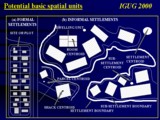
For examples of these services see the pages listed on the home directory: HomeGIS EducationAn Introductory level GIS course has been developed and is planned for presentation later this year again at the Nitric Industries sudoroom venue. See: http://sudoroom.com/coursesplanned Course: Introduction to ArcGIS with references to applications in exploration geology and other industries / research areas. Duration: 3 full day workshops / lectures Current dates (subject to possible change): 2010 May 3,4, 5 Topics covered: This courses covers all the basic concepts generally covered in introductory level GIS courses with a bias on earth science applications. Examples will be derived from other areas such as the oil and gas industry, catchment management, informal settlement upgrading and will be primarily based on the tutor’s involvement in the private and research sectors. While the basic lectures/ exercises will focus on introductory GIS level concepts, these sessions will be interspersed with brief presentations utilizing slightly more involved procedures – the aim thereof to show the student the potential of the GIS tool. The types of examples that will be touched on will include: Shuttle Radar Topography Mission (SRTM), landsat ETM, ASTER and other satellite imagery for base metal / diamond exploration; integration of aeromagnetics, gravity, geochemistry and other geological data for exploration; pipeline manangement in the North Sea; contouring of stream sediment data; proximity analysis associated with faults; groundwater-related thematic mapping; informal settlement density and growth rate spatial-temporal modelling etc. These side applications will touch on the possibilities of other ArcGIS modules such as Spatial Analyst and slightly on other GIS software. For further information please contact: Dr Iúma Martinez; uma@giscapetown.com; +27 +21 072 43 45 308 Reviews: 001 Sent: Thursday, January 21, 2010 10:22 AM " Thanks very much for all the trouble you went to. I found the course to be most beneficial in providing an insight into some of the many capabilities of the software and I am plan to use aspects of what I learned to practice soon (plan to play around with the data you provided as well as mess around with the aeromag data scales)...." Speciality: Groundwater (Pr.PmSA.Nat.Dip) 002 Sent: Thursday, January 21, 2010 10:36 AM "Hi, the course was very good in my opinion, it suited the audience you had basically people with a good knowledge of survey/geology/mining etc, might just be a touch to technical for lesser mortals!You really had to rush through the presentations which was a pity may be an idea to have things a little more structured time wise i.e. fixed breaks or perhaps an extra half day. A explanation of some of the acronyms might also be an idea not everyone would be familiar with all of them SRTM tripped me up! That said it was really very good and you ability to explain very complicated subjects really makes it go very well so please do not take the above as criticism well ok constructive I hope." Speciality: Offshore Surveying, Operations / Logistics Manager 003 Sent: Friday, January 22, 2010 12:35 PM " Yes, ... we are all agreed that the course allowed us to begin doing the basics of dabbling in ArcView but confirmed our feeling that the GIS work should be left to a specialist who is experienced in exploration GIS. I am pretty sure that I can now get geology, geophysics, topography & other existing maps scanned and registered. I can add any data I have collected in the field (geological mapping, sampling, geophysical) together with my GPS data and produce a shape file and probably a reasonable looking map for a report .... however, the finer arts of GIS are way beyond me. either database or spreadsheet software to organize data into a usable format...I think the course is correctly structured and covers the major features to get one started in GIS..." Speciality: Exploration Geology (B.Sc. (Hons) MBA Pr.Sci.Nat.) 004 Sent: Friday, January 22, 2010 2:46 PM "...I thought your presentation of a difficult subject was good and I think the practical approach is best. Personally I attended not to really learn about ArcMap and the Arc products but to see if you could make the programme more user friendly..." Speciality: Exploration Geology, Groundwater, Environmental Management (MSc.Pr.Sci.Nat) Project ManagementProject and logistic management services can be provided for field surveys and data collection in the oil & Gas and Mining related sectors (both onshore and offshore). The project management services which Giscapetown can offer include:
For further information please contact: Mr Eddie Guild; eddieguild@eject.co.za; +27 +21 082 25 87 042 |
|